
Description
|
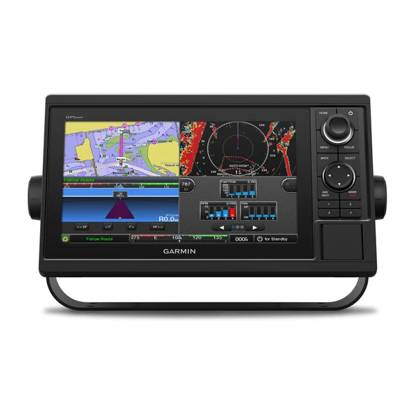
Garmin GPSMAP 1022 Chartplotter – Basemap 10-inch Chartplotter Is All-in-1 Solution
GPSMAP 1022 is designed for cruisers, sailors and sailing racers who need the advanced all-in-1 solution provided by our 10-inch keyed chartplotter. Features a large, bright screen coupled with a quick and easy-to-use keypad interface with user-programmable keys and a multifunction control knob. Complete Network Sharing Garmin Marine Network support allows sharing of sonar, maps, user data, dome or open-array radar, IP cameras and Panoptix™ sonar among multiple units. Includes NMEA 2000 network connectivity and NMEA 0183 support for autopilots, digital switching, weather, FUSION-Link, VHF, AIS and other sensors. Built-in Wi-Fi® and ANT® Connectivity You also enjoy built-in Wi-Fi and ANT wireless connectivity directly to quatix® marine watches, Garmin Nautix™ in-view display, gWind™ Wireless 2 transducer, GNX™ Wind marine instrument and wireless remote controls. You can even stream and control a VIRB action camera from the chartplotter. Heading, Position Refreshed 10 Times per Second Fast, responsive built-in 10 Hz GPS and GLONASS receiver refreshes your position and heading 10 times each second to make your movement on the screen more fluid. It makes dropping up to 5,000 accurate waypoints — and finding your way back to them — quick and easy. Upgrade to Our Best Maps on the Water Two SD™ card slots provide expandable memory for accessory map purchases, such as LakeVü HD, LakeVü HD Ultra, BlueChart® g2 HD or BlueChart® g2 Vision® HD, which adds Garmin patented Auto Guidance¹ and other great features. Built-in SailAssist Features To help you gain a wind-maximizing competitive edge, your chartplotter features a pre-race guidance page that shows your virtual starting line along with data fields showing laylines, time to burn before the start and a race timer that can be synchronized across all your networked Garmin GPS products. In addition, other supported sailing features include an enhanced wind rose, heading and course-over-ground lines, set and drift, true and apparent wind data and more. GPX Waypoints Transfer If you have waypoints, tracks or frequently used routes stored on another manufacturer’s GPS product — or on a Garmin handheld device — it’s easy to transfer those items to your new Garmin chartplotter via industry-standard GPX software formatting. ¹Auto Guidance is for planning purposes only and does not replace safe navigation operations. Specifications Physical & Performance |
Reviews
There are no reviews yet.